
Under almost every site in Qatar, Saudi Arabia, and the UAE runs a hidden network of power cables, water mains, sewers, gas lines, and telecom ducts. Break ground without knowing where they are and you risk a strike that stops the job, endangers the crew, and brings in the utility authority. An underground utilities survey maps those buried services before excavation starts, which is why it has become a standard first step on serious GCC projects rather than an afterthought.
In this article
What an underground utilities survey is
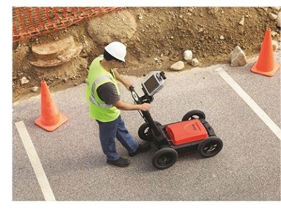
An underground utilities survey locates, identifies, and maps buried services without digging to find them. It uses non-destructive methods such as ground penetrating radar, electromagnetic locators, and GPS-based mapping to detect what is below and record its position, depth, and alignment. The result is a clear picture of the underground network tied to the site, so design and excavation can work around it. Our underground utilities survey service is built to give project teams that picture before anyone breaks ground.
Why it matters on GCC projects
Urban areas across the Gulf are densely built and the ground beneath them is congested, often with services laid by different authorities over many years. Mapping them poorly, or not at all, exposes a project to real risks:
- Accidental damage to live utilities, which is dangerous and expensive.
- Costly rework and delays when an unknown line is hit.
- Safety risks to workers and the public.
- Compliance problems with local authorities.
A survey replaces those risks with certainty, which keeps excavation safe, efficient, and within the rules.
The cheapest time to find a buried cable is on a drawing, not with an excavator bucket.
How the survey is done
A thorough survey combines methods, because no single tool finds everything. Electromagnetic locators trace metallic pipes and cables. Ground penetrating radar picks up both metallic and non-metallic services, including plastic pipes and concrete ducts that a locator would miss. The detected utilities are then tied to the site with precise survey equipment and delivered as clear CAD drawings, not rough marks on the ground. Used together, the methods cross-check each other, which is what makes the deliverable something a designer can actually rely on.
Integration with other surveys
Underground data is most useful when it sits alongside everything else known about the site. We integrate utility findings with topographic surveys, 3D laser scanning, BIM models, and digital mapping, so the team sees the surface and subsurface together. That complete view is what prevents the late surprises that come from planning each layer in isolation.
Where it is used
The service supports a wide range of work across Qatar, Saudi Arabia, and the UAE, including building and infrastructure construction, road and highway projects, utility installation and upgrades, urban development and smart-city work, and commercial and industrial builds. It matters most on congested sites, where the density of buried services leaves little room for a wrong assumption. An underground utilities survey is not just a technical box to tick. It is what lets developers and engineers proceed with confidence instead of digging blind, and it is central to safe, well-planned construction in the region.